


QField for QGIS

คำอธิบายของQField for QGIS
QField – การรวบรวมข้อมูล GIS ระดับมืออาชีพทำได้ง่าย
QField เป็นแอปมือถือขั้นสุดยอดสำหรับงานภาคสนาม GIS ระดับมืออาชีพที่มีประสิทธิภาพ สร้างขึ้นด้วยขุมพลังของ QGIS ทำให้นำโครงการ GIS ที่กำหนดค่าไว้อย่างเต็มรูปแบบมาสู่ปลายนิ้วของคุณ ทั้งแบบออนไลน์หรือออฟไลน์โดยสมบูรณ์
🔄 การซิงโครไนซ์คลาวด์แบบไม่มีรอยต่อ
ทำงานร่วมกันแบบเรียลไทม์ด้วย QFieldCloud—ซิงค์ข้อมูลและโครงการระหว่างภาคสนามและสำนักงานได้อย่างง่ายดาย แม้ในพื้นที่ห่างไกล การเปลี่ยนแปลงที่ทำแบบออฟไลน์จะถูกจัดเก็บและซิงค์โดยอัตโนมัติเมื่อการเชื่อมต่อกลับคืนมา
แม้ว่า QFieldCloud จะมอบประสบการณ์ที่ราบรื่นที่สุด ผู้ใช้ก็มีอิสระในการทำงานผ่านวิธีการที่ต้องการได้ QField รองรับการโหลดข้อมูลผ่าน USB, อีเมล, ดาวน์โหลด หรือการ์ด SD
📡 รองรับ GNSS ที่มีความแม่นยำสูง
บันทึกข้อมูลที่แม่นยำโดยใช้ GPS ภายในอุปกรณ์ของคุณหรือเชื่อมต่อเครื่องรับ GNSS ภายนอกผ่าน Bluetooth, TCP, UDP หรือตำแหน่งจำลอง
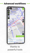
🗺️ คุณสมบัติหลัก:
• รองรับ .qgs, .qgz และโครงการ QGIS แบบฝัง
• แบบฟอร์มที่กำหนดเอง ธีมแผนที่ และเค้าโครงการพิมพ์
• การติดตามด้วย GPS แบบเรียลไทม์พร้อมระดับความสูง ความแม่นยำ และทิศทาง
• การแก้ไขข้อมูลเชิงพื้นที่แบบออฟไลน์ได้ทุกที่
• ซิงค์โปรเจ็กต์และการอัพเดตด้วย QFieldCloud (ตัวเลือกเสริม)
📦 รูปแบบที่รองรับ:
เวกเตอร์: GeoPackage, SpatiaLite, GeoJSON, KML, GPX, เชปไฟล์
แรสเตอร์: GeoTIFF, Geospatial PDF, WEBP, JPEG2000
🔧 ต้องการปรับแต่งหรือเพิ่มคุณสมบัติใหม่หรือไม่?
ติดต่อเราได้ที่ https://www.opengis.ch/contact/
🔐 การอนุญาต
QField อาจขอการเข้าถึงตำแหน่งเพื่อแสดงตำแหน่งของคุณและรวบรวมข้อมูลเชิงพื้นที่ รองรับ GNSS ภายนอกอย่างเต็มที่สำหรับความต้องการที่มีความแม่นยำสูง
❓ คำถามหรือประเด็นปัญหา?
รายงานข้อบกพร่องหรือขอคุณสมบัติได้ที่: https://qfield.org/issues
QField for QGIS--เวอร์ชั่น3.6.4 - Gondwana
(06-06-2025)
QField for QGIS - ข้อมูล APK
เวอร์ชั่น APK: 3.6.4 - Gondwanaแพ็คเกจ: ch.opengis.qfieldเวอร์ชั่นล่าสุดของQField for QGIS
เวอร์ชั่นอื่น


 3.55
3.55


แอปในประเภทเดียวกัน

คุณอาจจะชอบ...


